Geography & the World · Resources & land use
Aquifers and the water table
Groundwater sits in the pores of rock, not in caverns. See what an aquifer and the water table are, why some groundwater moves a foot a day, and why some is never replaced.
What you will learn
- Say what an aquifer is and why it isn't an underground lake
- Tell a confined aquifer from an unconfined one and name what separates them
- Define the water table and say how it can be observed
- Explain why the water table isn't flat and isn't the same as a water level
Lesson 1 of 4 · 5 min
An aquifer is wet rock, not an underground lake
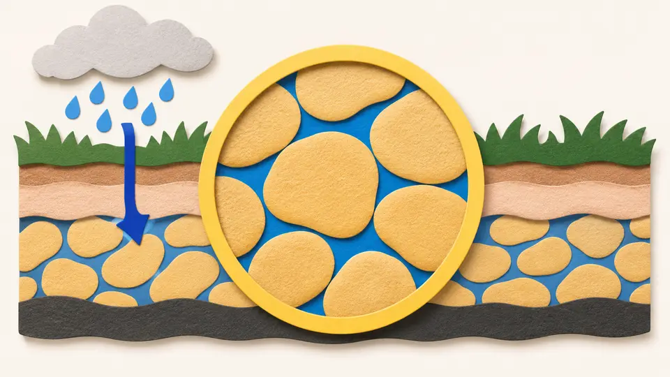
Picture the water under your feet and you probably see a dark lake in a cave. Drill down to it and you'd find wet rock. An aquifer is an underground layer of rock, gravel, sand or silt with water filling the gaps in it.
The name says as much. It joins the Latin aqua, water, to a suffix meaning bearing, so an aquifer is water-bearing ground. Underground rivers do exist, in caves beneath limestone country, but they're the extreme case.
Aquifers are found from just below the surface to more than 9,000 meters down. The shallow ones are the ones people use most, for water supply and for irrigation. They're also the ones most likely to be refilled by local rain. That refilling is called recharge.
The layers that block water matter as much as the ones that hold it. An aquitard is a layer of clay or dense rock that water passes through only very slowly. It restricts the flow from one aquifer to the next.
Those layers give aquifers their main division. An unconfined aquifer has no such barrier right above it. Its top is the water table, the level below which the ground is saturated, and that level rises when rain soaks in.
A confined aquifer has an impermeable barrier on top, which stops the water in the rock from rising any higher and can hold it under pressure.
The label describes a place. One layer of rock can be confined in one area and unconfined in another, depending on what lies above it there.
Try to recallTwo wells drilled into what maps show as the same geological formation behave differently. In one, the water level rises after heavy rain. In the other, it doesn't. Does that mean one of the measurements is wrong?
Not necessarily. The same rock formation can hold an aquifer that's confined in one area and unconfined in another. Where it's unconfined, nothing impermeable lies right above it, so the water level rises when rain soaks in. Where an impermeable barrier such as clay lies on top, that barrier stops the water in the rock from rising. Whether the barrier is there is a local fact.
So forget the cave. An aquifer is rock with water in its gaps. The first thing to ask about any spot is whether an impermeable layer lies on top, because that decides whether rain can raise the water level there.
Lessons in this topic
An aquifer is wet rock, not an underground lake
Most people picture groundwater as a lake in a cave. See what's really down there, and what changes when a layer of clay or dense rock sits on top.
What the water table is, and why it isn't flat
The water table is the level below which the ground is soaked. See how to find it, why it follows the hills, and why a deep well can show a different level.
Why some groundwater creeps and some races
Groundwater in sand moves about a foot a day, and in limestone it can cover kilometers. See why the speed depends on how the openings in the rock connect.
Shared aquifers and water that never comes back
Aquifers cross borders as easily as rivers, and some hold water that rain no longer replaces. See why hidden water is hard to share and what pumping it too fast costs.
Three quick stories from this topic
A forearm a day
Groundwater in sand moves about a forearm's length on a fast day
One foot a day, about 0.3 meters, counts as a high rate for water seeping between sand grains. In limestone, where weak acid in the water dissolves the rock into channels, dye tests have clocked groundwater at up to 11 kilometers a day.
Karst water moves kilometers a day
Carbonic acid widens fissures in limestone, which lets in more water, which widens them further. Dye traces in the Barton Springs Edwards aquifer measured 0.8 to 11.3 kilometers per day.
Why karst aquifers are vulnerable
Their rapid flow makes karst aquifers much more sensitive to contamination, and models that assume uniform porosity don't apply to them.
Six thousand years to refill
The Ogallala Aquifer under the central US would take about 6,000 years to refill
It lies beneath parts of eight states and holds mostly water left from the last ice age. In its drier parts, rain replaces only about 10% of what is pumped out each year. The refill time is scientists' estimate for natural processes.
Fossil water
Fossil water is groundwater that has stayed in an aquifer for thousands of years. It lies too deep for present-day rain to renew, so any pumping lowers the water table permanently.
Faster this century
A 2013 report by the US Geological Survey found that the Ogallala's depletion from 2001 to 2008 was about 32% of its depletion during the whole 20th century.
Berlin's pink pipes
The pink pipes above Berlin's streets carry groundwater pumped out of building sites
Berlin's water table lies only a few meters below the surface, so a deep excavation fills with water. Builders pump it out and send it through pink or blue pipes to the river Spree. The water table is the level below which the ground is saturated.
How to find the water table
Sink a wide pipe into the ground, open at the top. Water settles in it at the level of the water table.
Where it comes out
The water table roughly follows the land and slopes toward rivers. Springs, lakes and oases occur where it reaches the surface.
Sources
- Aquifer, Wikimedia Foundation
- Water table, Wikimedia Foundation
- The Ogallala Aquifer: Saving a Vital U.S. Water Source, Scientific American
- The Mysteries of Berlin, visitBerlin