Geography & the World · Landscapes & waterways
Why a river abandons its own channel
Rivers switch course, sometimes moving their mouths by hundreds of kilometers. See why a growing delta makes its own channel unstable, what a delta's branches record, and how floodgates hold the Mississippi where it is.
What you will learn
- Define avulsion and say what distinguishes a full one from a partial one
- Trace the two reasons a lengthening delta lobe makes its own channel unstable
- Define a distributary and tell it apart from a tributary
- Explain how repeated switching gives a mature delta its distributary network
Lesson 1 of 4 · 6 min
How a river leaves its channel for a new one
Between 595 BC and 1946, China's Yellow River changed course 26 times, by one count. Its mouth moved by as much as 480 kilometers, reaching the sea sometimes north of the Shandong Peninsula and sometimes south of it.
A river that does this hasn't just flooded. It has left its channel and started down a different one. Geologists call that an avulsion.
The word means something specific. Water is diverted out of an established channel into a new course at a bifurcation, a point where the channel splits. A flood that spills over and drains back doesn't count. Neither does a bend creeping sideways a few meters a year.
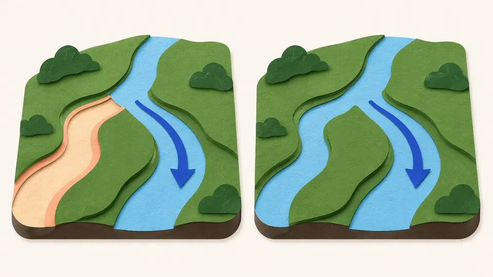
Avulsions come in two kinds. In a full avulsion, all the flow moves to the new channel and the old bed goes dry. In a partial one, only part of the flow moves, and both channels keep carrying water.
Slope helps decide which you get. Slope is how steeply a channel drops along its length. Where the new course is about as steep as the old one, the result is a partial avulsion. A much steeper new course can take the whole river.
Geologists once thought slope explained everything. They now know the shape of the channel matters too, and so do blockages such as fallen wood or beaver dams.
Avulsions are common in river deltas, where a river drops its sediment as it meets the sea and the channel slopes are very gentle. There the process is called delta switching.
The river builds a lobe, a tongue of new land pushing out to sea. As the lobe grows, the channel across it gets longer, while the drop in height from start to finish stays the same. A longer run over the same drop means a gentler slope.
The gentler slope undermines the channel in two ways. The first is geometry. Water takes the most direct way downhill, and a shorter route to the sea is now steeper than the channel. If a flood breaks the natural levees, the ridges of sediment along the banks, a better path is waiting.
The second is sediment. Slower water puts less shear stress on the bed, meaning it drags on the bottom less. So more sediment settles inside the channel, and the bed rises above the floodplain around it. That makes the levees easier to breach.
So the lobe's own growth prepares its abandonment.
Try to recallExplain why pushing a delta lobe farther out to sea makes the channel feeding it more likely to be abandoned.
Advancing the lobe lengthens the channel without changing the height it falls through, so the slope of the channel drops. That has two consequences. A shorter route to the sea is now steeper, so water that breaks the natural levees has a better path to take. And slower water puts less shear stress on the bed, so more sediment settles inside the channel and the bed rises above the floodplain, which makes a breach easier. Both effects grow as the lobe grows.
After the switch, the new channel carries the sediment and builds a new lobe somewhere else. The abandoned lobe, cut off from its supply, slowly subsides.
The Mississippi did this over and over. Before levees walled it in, it switched to a shorter route to the Gulf of Mexico about every 1,000 to 1,500 years.
Lessons in this topic
How a river leaves its channel for a new one
An avulsion is a river leaving its channel for a new course. See what counts as one, and why a growing delta makes its own channel unstable.
Why a delta splits into so many branches
A tributary joins a river and a distributary leaves it. See why deltas are full of distributaries, and what each branch records.
When a riverbed rises above the land around it
Once a river's bed sits one channel depth above its floodplain, a levee breach becomes a new river. See why, and how a single flood can also cut a new course outright.
The floodgates that keep the Mississippi in its channel
The Atchafalaya offers the Mississippi a shorter, steeper route to the Gulf. See how it captured a growing share of the river, and what the 1963 control structure does and does not fix.
Three quick stories from this topic
The river that moved 26 times
China's Yellow River shifted its course 26 times between 595 BC and 1946, by one reckoning
Its mouth moved by as much as 480 kilometers. The river drops so much silt on its own bed that the bed came to sit higher than the countryside beside it. When the levees broke, the water could not drain back, and the river could take a new course.
One channel depth
Geologists have a rule of thumb. Once a river's bed has risen about one channel depth above its floodplain, any breach of the levees becomes a new river instead of a flood that drains away.
Higher levees, higher stakes
Raising the levees kept the Yellow River in place for a time, while the bed between them kept rising. That made each eventual break worse.
Holding the Mississippi
Floodgates finished in 1963 keep the Mississippi from taking a shorter route to the sea
A side branch, the Atchafalaya, offers a steeper path to the Gulf of Mexico. Its share of the flow grew from under 10% in 1850 to about 30% by 1950. The Old River Control Structure has held it near 30% since, keeping the river flowing past Baton Rouge and New Orleans.
A forecast with a date
In 1953 the US Army Corps of Engineers concluded that, left alone, the Mississippi could change its main course to the Atchafalaya by 1990.
The cause is still there
The gates control how much water takes each route. The Atchafalaya route is still the shorter and steeper one, and the flood of 1973 almost caused the structure to fail.
One creek, two oceans
A creek in Wyoming splits in two, and its branches drain to the Atlantic and the Pacific
North Two Ocean Creek divides on the Continental Divide at a spot called Parting of the Waters. Water in Atlantic Creek travels 3,488 miles to the Gulf of Mexico. Water in Pacific Creek travels 1,353 miles to the Pacific. Branches that leave a stream like this are distributaries.
The opposite of a tributary
A tributary flows toward a river and into it. A distributary branches off and flows away. Direction decides the name, and size has nothing to do with it.
Where most of them are
Distributaries are most common in deltas. Each time a river switches course, some water can stay in the old channel, so the branches pile up.
Sources
- Avulsion (river), Wikimedia Foundation
- Yellow River, Wikimedia Foundation
- Distributary, Wikimedia Foundation
- Mississippi River Delta, Wikimedia Foundation
- Old River Control Structure, Wikimedia Foundation
- Parting of the Waters, Wikimedia Foundation